 |
| 
|
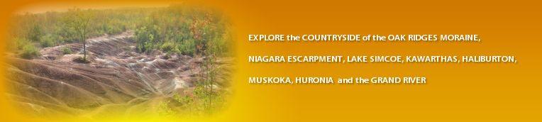
A Drive north-east of Markham
A countryside drive into the Oak Ridges Moraine
going through Stouffville, Uxbridge, Goodwood
circa 105 km; 2 hours driving;
Please obey all current Covid-19 regulations
1 Begin at the intersection of Highway 7 and Main Street Unionville
- Drive north on Main Street Unionville - follow the summer detour - avoiding the shopping area
2 Turn right (east) onto Carlton Road
Help hint - the Varley Art Gallery of Markham, Rouge Valley Trail and the Villages and Valley Walking and Cycling Loop (markham.ca/getactive) are at, or near, this intersection.
3 Turn left (north) onto Kennedy Road (RR3)(traffic lights)
- cross 16th Ave (RR 73)
- cross Major Mackenzie Dr (RR 25)
- pass on left Angus Glen Golf Club (twice used for the Canadian Open)
- cross Elgin Mills Rd
- cross 19th Ave
You enter the Oak Ridge Moraine and will remain in it for most of this drive; look for the rolling landscape.
- cross Stouffville Road (RR14)
Side trip to left (west) for 1.3 km to visit Bruces Mill C.A. (entrance fee)
4 Turn right (east) onto Bethesda SR
Help hint - you will notice the numerous ponds along this stretch of road. This is a natural phenomenon. The houses have been referred to as the Floating Mansions of Lemonville
- cross McCowan Rd on a left/right jog in the route
Side trip to right (south) for 1.5 km to visit Applewood Farm and Winery
5 Turn right (south) onto Markham Rd (Hwy 48)
6 Turn left (east) onto Bethesda SR
- pass on left Willow Springs Winery
7 Turn right (south) onto 9th Line (RR 69)
- cross Bayberry St - at a roundabout
- cross Millard St (traffic lights)
8 Turn left (east) onto Main St (Stouffville Rd) and drive through the town of Stouffville
- pass on left the southern terminus of the York Durham Heritage Railway
- cross Reesor Rd / 10th Line
9 Turn left onto York / Durham Line (RR 30)(T-junction)
10 Turn right (east) onto Webb Rd
You have now left York Region and are in Durham Region
- cross 2nd Concession (historic hamlet of Glasgow)
Side trip to right (south) for 0.2 km to visit Rouge National Urban Park
- cross West Duffins Creek
- cross 3rd Concession
- cross 4th Concession
11 Turn left (north) onto Brock Rd (RR1)(T-junction)
- pass on right Pathways on Pleasure Valley (horse back riding)
12 Turn right (east) onto Allbright Rd
13 Turn left (north) onto Concession 6 (T-junction)
- pass on left an entrance to Durham Regional Forest (North Walker Woods) (limited roadside parking)
14 Turn right (east) onto Goodwood Rd (RR 21) (no sign; busy road)
15 Turn right (south) onto Concession 7 (traffic lights)
Side trip - turn left (north) for 400 m to see Pine Grove Church (1878)
- pass on left two entrances to Durham Regional Forest (Main Tract)(parking)
- road curves to the right and then to the left
- pass on right parking area for East Walker Woods; Trailhead of East Duffins Creek Headwaters
- winding road
16 Turn left (east) onto Chalk Lake Rd
Side trip - straight ahead for 500 m to see Glen Major Church (1873)
- winding road
- pass on left Skyloft Ski Resort
- pass on left Lakeridge Ski Resort
- pass on left parking lot for Chalk Lake Spring (for spring-fed water)
17 Turn left (north) onto Lake Ridge Rd (RR 23)
- pass on left Houston Rd
- cross Goodwood Rd (RR21) (traffic lights)
- pass on left Reid Rd
- pass on right Line 6
- pass on left Wagg Rd
- cross Medd Rd / Foxfire Chase
- pass on right Line 8 (Ward Rd)
18 Turn left (west) onto Reach Rd (RR 8)(traffic lights)
19 Turn right (north) onto Main St (RR1)(Uxbridge)
Uxbridge is famous for its trails (discoveruxbridge.ca/trails)
20 Turn left (west) onto Brock St. (traffic lights)
Detour if there are ROAD WORKS on BROCK ST
20 cross Brock St
20A Turn left (west) onto Dominion St
20B Turn left (south) onto Toronto St
20C At the traffic lights - Turn right (west) onto Brock St
continue as below by passing on right Railway St
Side trip - continue straight ahead on Main St and drive 5.6 km to see the Fosters Memorial and 10.9 km to Leaksdale for the Lucy Maude Montgomery Museum
- cross Toronto St (traffic lights)
- pass on right Railway St
Side Trip - turn right for the northern terminus of the York Durham Heritage Railway
- cross South Balsam St / Quaker Village Dr (traffic lights)
21 Turn left (south) onto Conc. Rd 6 at a roundabout
Side trip - turn right onto Conc. Rd 6 for Uxbridge Historical Centre Museum
- pass on right historic Quaker Meeting House (a faith building, similar to a church)
- cross heritage railway tracks
22 Turn right (west) onto RR47(traffic lights)
- road curves left (south)
- cross Wagg Rd
- road curves right (west)
and pass on left RR1 (Brock Rd)
- cross Concession 4
- pass on left Richters Herbs
- cross Concession 3 in hamlet of Goodwood (TVs Schitts Creek)
- cross heritage railway
- pass on left Goodwood Rd (RR 21)(traffic lights)
- cross Concession 2
- cross York Durham Line (RR 30)
You now leave Durham Region and re-enter York Region
the road is now Bloomington Rd (RR40)
- cross 9th Line
- cross Hwy 48
- cross McCowan Road
23 Turn left (south) onto Kennedy Rd (traffic lights)
- cross Bethesda SR
- cross Stouffville Rd
You will leave the Oak Ridge Moraine
- cross 19th Ave
- cross Elgin Mills Rd
- cross Major Mackenzie Dr
- cross 16th Ave
24 Arrive at Kennedy Rd and Hwy 7 in Markham
 |